Flood Hazard
The National Flood Insurance Program (NFIP)
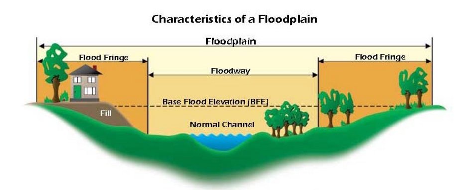
Periodically, rivers, streams and lakes will overflow their banks and inundate adjacent land areas. These areas, known as floodplains, temporarily store this excess water. Flood damages occur only when man interferes with the natural flooding process by altering the watercourse, developing areas in the upper watershed, and/or building inappropriately in the floodplain itself.
The traditional solution to flood problems has been to build structural protection works such as dams, diversions, levees and flood walls. Despite tremendous expenditures for these structural projects, economic flood losses have continued to increase year after year. Given this, governments at every level have begun to see the solution to avoiding flood damages lies not in keeping the water away from people, but rather in keeping people away from the water. This philosophical shift lead to the creation of the National Flood Insurance Program (NFIP) in 1968, thereby codifying the concept of floodplain management.
The base flood, sometimes referred to as the 100-year flood, has a 1% chance of occurring in any given year. Although a 100-year flood sounds remote, keep in mind that over the life of an average 30-year mortgage, a home located within the 100-year flood zone (A or V zone) has a 26% chance of being inundated by the base flood. This same home has less than a 1% chance of fire damage during the same period.
The Flood Smart website is a good source of information for those having flood insurance. Read through and understand flood insurance.
Find out if your property is in a floodplain. Visit the FEMA website to determine your status.
Advocate@fema.dhs.gov. Contact the FEMA Flood Insurance Advocate for problems with flood insurance or flood maps.
More Information
FEMA FORMS - Get the latest version of the Elevation Certificate, LOMA, LOMR and more by visiting FEMA's website.
County Floodplain Development Permit Application - For those properties that are within the flood hazard area, a County Floodplain Development Permit is required.
NFIP - Learn all about the technical features of flood proofing and other building issues when developing in the special flood hazard areas. These bulletins give the details to be compliant with local, State and Federal standards. Below is a link to the bulletins.
Flood Insurance Study - Volume 1 & 2
A Flood Insurance Study (FIS) is a book that contains information regarding flooding in a community and is developed in conjunction with the Flood Insurance Rate Map (FIRM). The FIS, also known as a flood elevation study, frequently contains a narrative of the flood history of a community and discusses the engineering methods used to develop the FIRMs. The study also contains flood profiles for studied flooding sources and can be used to determine Base Flood Elevations for some areas.
NEW FLOOD INSURANCE STUDY. The Flood Insurance Study that has been completed for the new FIRMs is now available for review. This FIS will be effective September 3, 2010 but is here for reference. The new FIS brings all of the County, Incorporated Cities and the CTUIR (Tribe) together.
Helpful Links
National Flood Insurance Program (NFIP) Floodplain Management Requirements (FEMA 450) - This is the desk reference and is a very large binder of materials.
Guide to Flood Maps (FEMA 258) - This reference item provides more details on reading and understanding flood maps.